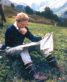
Long Rider Jeremy James studies his maps
intently, relying on traditional methods to plot his course from Turkey to
Wales in 1987.
The Long Riders' Guild Equestrian Cartographic Collection
|
|
The Long Riders' Guild Equestrian Cartographic Collection |
New Expedition Route and Social Support Plans developed by international team of Long Riders
Long Riders make Cartographic Equestrian History
We have an old joke at The Long Riders’ Guild. While it’s true that the world’s equestrian explorers are participating in a Bronze Age activity, Members of the Guild are always the first to incorporate the latest fascinating 21st century technological advance into our equestrian journeys. Accordingly, the earth’s mounted explorers have long been using solar power, digital imaging, satellite technology and internet advantages. This revolutionary adaptation of past and present often leads the Guild to jokingly tell reporters that being a Long Rider is a stunning mixture of “Genghis Khan meets the Matrix.”
But even those previous developments pale compared to the latest technological breakthrough.
As with so many of the valuable ideas shared between Long Riders, the careful study of a previous equestrian explorer’s wisdom often leads to a break-through method used by a subsequent traveller.
Nothing symbolizes this sharing of thought and development better than the recent technological route & social development plan inspired by The Guild and constructed by a first-time equestrian traveller. Using concepts previously experimented with by Long Riders Jeremy James and Andi Mills, he mapped out his route across North America in advance of his ride. He managed this by incorporating various aspects of the Google mapping technology with work done by his Long Rider predecessors.
But how does it work?
This advance mapping technique will now become part of the “How to Plan an Equestrian Expedition” page on The Guild’s website.
Yet what gives this technique even more emotional resonance is that two Long Riders helped formulate the idea. The back story began in July, 2007 when the legendary Long Rider and “Poet of the Saddle,” Jeremy James, sent an excited email to Guild HQ.
“I have been aware for some time of Google Earth and have dipped in to it from time to time. Well, tonight I explored it properly. I could not believe it. For a traveller on horseback it is of incredible value. I had not realised that you could pitch the thing on a horizontal axis and get an accurate topographical view of the landscape.
What !
Anywhere in the world ?
Absolutely !
This would enable a Long Rider to see the terrain you will cross before you set out. Roads, rivers motorways - the lot. Ranges, passes, villages, fields, boundaries - everything. Blind passes, snow blocks, tracks, paths - incredible. It is almost impossible to comprehend.
I have been able to see on my computer the very route I took with my own horse from Turkey to Wales and how badly wrong I went immediately. Using this new technology I could see at an instant where I should have gone instead and why I made the mistake,” Jeremy wrote.
He then went on to share his belief in how this cartographic development might be of massive historical importance to equestrian travellers.
“I suddenly realized that the Google mapping technology could be the take-off point for a HUGE launch in horseback travel. Why? Because it means that predetermined routes can be created in advance!,” the excited Long Rider predicted.
Jeremy went on to explain how he believed that Long Riders could augment the original Google topographical information by photographing and correlating accurate information on horse-friendly rest stops, available water and accessible bridle paths, as well as noting places and hazards other equestrian explorers should avoid. Using this method, Jeremy explained, “everything can be mapped through the individual effort of each traveller.”
The result, Jeremy believes, “could revolutionize the concept of equestrian travel and bring it slap-bang into the 21st century by demonstrating that Russia, Iran, The Balkans, Eastern Europe, China, anywhere, can be safely mapped for horses”
It didn’t take but an instant for The Long Riders’ Guild to attempt to turn Jeremy’s idea into a reality. We did this by asking North American Long Rider Andi Mills to incorporate Jeremy’s idea into the journey she was making across the American Southwest.
“I think the Google Earth idea is wonderful,” she emailed The Guild while in the saddle. But though Andi was willing to try and use the new idea to construct a map, she was constrained by the time she had free while on the journey, as well as the limitations of her computer equipment.
“I am having some trouble with the program on my computer. It is slowing me down a lot and I don't have high enough definition to get a really clear picture close up.”
Ultimately Andi’s journey ended earlier than she planned, thus prohibiting her from incorporating Jeremy’s idea into her trip. But she resolved to continue working on the idea once she and her horse returned to their home in North Carolina.
“I am anxious to get home and begin work on this idea there. I think I can map out everywhere we have been in such a way as to bypass the areas we had trouble in and thereby create a safe route for someone who wanted to ride where we did,” Andi wrote.
Yet before Andi could study the problem, the Swiss Long Rider, Jessica Bigler, rode straight into trouble while trying to ride across England. Due to the fact that so many of the nation’s bridleways were unmarked or blocked, Jessica’s journey from Switzerland to Ireland ended prematurely.
The well-known Scottish Long Rider, Vyv Wood-Gee, who had attempted to assist Jessica, realized that there was a dire need for reliable equestrian travel information. She wrote to The Guild to say, ”It's obvious that those from outside Britain may not appreciate in advance how the UK differs from other countries, as finding out about routes in this country is not easy. I have had real difficulty finding out about riding routes in other countries, the legal position regarding equestrian access, knowing who to ask etc. Some may feel that finding such things out is all part of the challenge and satisfaction, as indeed it is, but basic information could help riders such as Jessica plan their ride so they don't meet such major disappointment. My suggestion is to include basic information on the LRG web-site, volunteered by Long Riders, regarding riding in different countries. Examples of the information which would be useful would be: how and where to find out about riding routes or other info relevant to that country, basic considerations in planning a ride in any country such as timing, weather, health, water etc.”
The experienced Scottish Long Rider, who has ridden from John O’Groat’s, Scotland, to Land’s End, England, summarized the basic tactical need of all equestrian explorers when she said, “I am well aware that nothing and no-one can be all things to all men, but we should learn from Jessica's experience and do something practical about it in terms of information sharing."
North American Long Rider Andi Mills had to this to say about these exciting events.
“This is great ! And what a supportive group. It demonstrates one of the best things about the Long Riders is the way they band together, bringing together so many different types of people with one huge common thread – equestrian exploration.”
The Long Riders’ Guild is now proposing the creation of an equestrian cartographic database. This unique equestrian effort will consist of two stages, documenting the past and mapping the future.
The first stage will consist of inviting all Members of the Guild to share the details of where they rode. To do this, Long Riders will be asked to provide The Guild with an itinerary of their journey. Though local conditions might have changed since these journeys were undertaken, nevertheless the general route will be available for future travellers. Several Long Riders are already preparing these tactical horse maps, including:
North American Long Rider Andi Mills, who rode across the deserts of the American Southwest –
Swiss Long Rider Basha O’Reilly, who rode from Russia to England -
British Long Rider Mefo Phillips, who rode from Canterbury to Rome -
British Long Rider Penny Turner, who rode across Greece –
British Long Rider Vyv Wood-Gee, who rode from Land’s End, England to John O’Groats, Scotland and
North American Long Rider Howard Wooldridge, the only person ever to ride “ocean to ocean” across the United States in both directions.
Each Long Rider’s route will contain details about where they travelled and will be obtainable from The Long Riders Route Directory via a link provided at the bottom of this page.
Furthermore, if a new Long Rider wishes to re-ride this route, then The Guild asks that they augment the basic first-generation information via the use of GPS and Google mapping technology, thereby creating a more accurate equestrian travel map.
The second stage will consist of asking would-be Long Riders to note their itinerary, and if they use new mapping technology, to provide this combination of information to The Guild’s cartographic database.
Billy Brenchley and Christie Henchie, who are riding from Tunisia to South Africa, have emailed The Guild to report that they too want to participate by mapping their route across that hazardous continent.
“What an exciting project! You can count us in!” the equestrian explorers said.
In a very short time this new repository will contain the routes laid out around the world by our Members. Such an unprecedented equestrian effort will allow future equestrian travellers to travel with an increased degree of safety between distant destinations and each route will be named by and/or for the Long Rider who created, mapped, confirmed and rode it.
If it is true that the age of national exploration is now past, The Long Riders’ Guild believes we are about to witness the dawning of the age of the citizen-explorer, an enlightened era wherein individuals set out not to exploit the natural resources of their neighbours, nor to plant the flag of their country of origin atop a mighty peak in another land, but rather to explore the frontiers of this planet and our own souls.
And having a trustworthy map is a great place to begin such an exploration.
Please click here to read the recommended method of constructing a Expedition Route and Social Support Plan.
To discover the routes previously ridden by Long Riders, please click here.
Here is some information on crossing borders.