Misty’s Long Ride
Ocean to Ocean – East to West
by
Long Rider Howard Wooldridge
|
Misty’s Long Ride
Ocean to Ocean – East to West by Long Rider Howard Wooldridge |
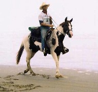
In 2002 North American Long Rider Howard Wooldridge rode “Ocean to Ocean” for the first time when he, and his one-eyed mare, Misty, successfully journeyed from the Atlantic Ocean in the state of Georgia to the Pacific ocean in the state of Oregon. To read about their journey, click here and to learn more about “Misty’s Long Ride” click here.
Most people would have been satisfied with having made the ride which Captain Willard Glazier made famous in 1875. That is the year the former cavalryman first rode, and coined the phrase, “Ocean to Ocean”
Yet Howard went on to outride the cavalry by becoming the first documented Long Rider to have ever ridden from one sea to the other IN BOTH DIRECTIONS! The rugged Long Rider accomplished that feat in 2005 when he rode from the Pacific ocean in the state of California to the Atlantic ocean in the state of New York. To learn more about Howard’s second journey, click here
In response to The Long Riders’ Guild’s request for our Members to share cartographic details regarding the routes they have ridden, Howard has provided the following information regarding his original Atlantic to Pacific ride.
North American route: SE to NW, about 3100 miles or 5,200 KM: time needed 6 months
Georgia:
Begin at the Atlantic Ocean 200 yards from road
Tybee Island, GA: US 80 west
Savannah: local roads thru city
Pooler: 80 west
Statesboro: 80 west
Dublin: turn north on US 441
Milledgeville: 441
441 & 129 join in middle of nowhere
Athens: 129 north
Jefferson: 129
Cleveland: 129
19 & 129 join in middle of nowhere
Blairsville: go west on US 76
411 & 76 join: go 411 north & 76 west
Chatsworth: stay on 76 west
Dalton: 41 north
Tunnel Hill: 41 north
Ringgold: 41 north
Left on GA 2 towards Fort Oglethorpe
Fort Oglethorpe: GA 2 west
Right turn on GA 193 to Tennessee border
Tennessee:
GA becomes Saint Elmo Street in city of Chattanooga. .go about 2 miles
West on US 11
US 11 combines with US 64 (along TN River)
Over first tall bridge at Haletown
Jasper: stay on 64 west
Kimball: 64 west
Pass under Interstate 24 and then watch carefully for Stagecoach Road to turn left & begin going up mountain
At TN 156 turn right towards Monteagle
Turn right on TN 15 & US 41
Monteagle: take TN 2 & US 41 to go down the mountain (north & west)
Pelham: 41 & 2
Manchester: US 41
Beechgrove: US 41
Murfreesboro: left turn onto West TN 96
Right turn on Alt. US 31…middle of nowhere
Nolensville: Alt 31
Left turn – Harding Place (near Nashville)
Left turn - US 70 (Post Road)
Bear right on Harding Pike (US 70 & TN 1)
Under Interstate 40
Pegram: US 70 & TN 1
Dickson: 70 & 1
Huntingdon: turn onto north TN 22
Martin: turn north onto US 45
Fulton: turn north onto US 51
Wickliffe: 51
Tall Bridge over Ohio River
Illinois:
Cairo: IL 3 North to Thebes
Thebes: 3
Left turn onto IL 146 towards Cap Girardeau
Missouri:
Cape Girardeau: US 61 north to Jackson
Uniontown: 61
Ste. Genevieve: 61
Festus: US 67 north
Near Arnold: left turn onto MO 141 toward Fenton
Fenton: 141
Left turn onto Conway Rd (just after passing US 40/Interstate 64)
Chesterfield: move onto Chesterfield Airport Rd WB
Turn right onto US 40/ US 61 in order to cross Missouri River (last tall bridge) west
Wentzville: 61
Troy: 61
Hannibal: turn left on US 36 west
St. Joseph: 36
Kansas:
St. Francis: 36
Colorado:
Idalia: 36
Watkins: 36
West of Watkins > move onto Business Interstate 70 (Colfax Ave)
Colfax Ave thru downtown Denver (US 40)
US 40 past Golden
Idaho Springs: US 40
Go WB US 40 to Empire
Steamboat Springs: 40
Craig: 40
Utah:
Vernal: 40
Heber City: 40
Just before I 80, exit to the north and there is a rail trail w/in ½ mile of US 40…go left on rail trail
w/o Coalville, rail trail ends, use nearby road (Echo Road) toward Morgan
e/o Morgan must take I-84 (ask locals for exact exit)
I 84 & exit at US 89 to South Ogden
US 89 to Brigham City
Various streets thru Brigham City
Utah 38 to Tremonton
WB on Main Street into Tremonton
Any entrance onto I -84 WB
84 to Snowville
Idaho:
I-84 to sublet (fence can be unwired at exit to allow staying at the truck stop—I cut it)
I -84 to I -86 merge & go WB on I-84
Exit at ID 77, go SB to Declo
Turn right WB onto ID 81 & into Burley
Merge with US 30 & continue WB
Twin Falls: 30
Bliss: US 30
Enter I-84 WB
Exit at Hammett & take US 30 towards Mountain Home
Enter I-84 at interchange 90
Exit at first Boise interchange (57)
City streets of Boise ending up on WB Franklin road to Nampa
Right turn –NB – on Can Ada Road to US 20
Left turn on US 20 towards Caldwell & 20 thru town
WB 20 to Notus & Parma
20 over Snake River at Nyssa
Oregon:
US 20 into Nyssa
20 to Vale
Turn right onto US 26 towards Brogan
26 to John Day
26 to Prineville
OR: 126 WB to Redmond & Sisters
US 20 Sweet Home & Albany
20 to Philomath
20 to Trapp Creek Road (DO NOT take US 20 into Newport)
Right turn on Devil’s Well Road into Elk City village
OR 539 to Toledo
Thru Toledo, then onto Yaquina Bay Road
Into port of Newport. See tall bridge & find your way to the Pacific Ocean.
